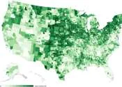
No level of lead exposure is considered safe for a child. Even trace amounts in the blood can impair development, damage the nervous system and leave lasting scars on learning and behaviour. Yet reliable data on where children are most at risk has long been patchy, making it difficult for health officials to target their efforts where they are needed most.
A new mapping project aims to close that gap, charting the risk of childhood lead exposure across the United States at the level of individual neighbourhoods. By combining housing records, environmental data and blood-testing results, researchers have built a detailed picture of which communities face the greatest danger — often those living in older homes with deteriorating paint, or near industrial sites with a legacy of contamination. The map is more than an academic exercise. It gives policymakers, pediatricians and parents a practical tool for prioritising testing, remediation and prevention, ensuring that the children most exposed to this silent hazard are the first to be protected.